Power lines. Cell towers. Oil and gas pipelines. Railways. Methane detection – all of these and so many other types of industrial inspection are made easier, safer, and more efficient with Skypro unmanned aerial systems.


Inspection & Surveying
Large, complex structures are best surveyed from the air. It’s no wonder that inspection has been one of the first UAV applications to be quickly and widely embraced world-wide.
ACCURATE, SAFE AERIAL INSPECTIONS IN MINUTES
UAVs are revolutionizing the inspection industry. Below are just a few of the inspection types users complete with our systems:
WIND TURBINE / WINDMILL INSPECTIONS
SOLAR PANEL INSPECTIONS
BRIDGE INSPECTIONS
RAILWAY / TRAIN LINE INSPECTIONS
OIL PIPELINE INSPECTIONS
GAS PIPELINE INSPECTIONS
METHANE GAS INSPECTIONS
COOLING TOWER INSPECTIONS
CRITICAL INFRASTRUCTURE INSPECTIONS
RAILWAY / TRAIN LINE INSPECTIONS
MONUMENT INSPECTIONS
RADIATION MEASUREMENT AND MONITORING
We use different sensors and cameras for specific industrial applications.
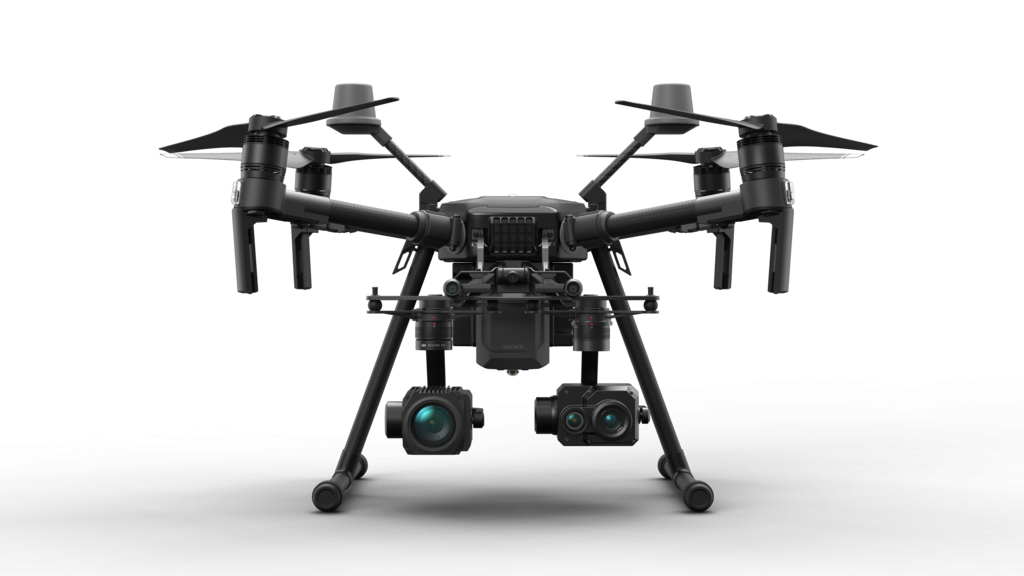
We utilize DJI Matrice 210 V2 and custom octocopter systems with multiple payload options. Designed for easy use, quick deployment, and intense accuracy, our kit makes it simple, fast, and cost-effective to collect the information your organization needs.
Using the optional waypoint navigation mode, users can inspect structures autonomously, providing a rapid yet thorough inspection.
With a RTK equipped drones it is even possible to inspect high voltage power lines and wind turbines. Our systems have undergone rigorous testing – their electronics can withstand electrical fields up to 380kV and are unaffected by magnetic fields.
At 1cm / pixel resolution, our drone deliverables lead the industry in precision: Turn-around time can be as short as just a few hours. Whether the project is a 100 mile pipeline inspection, mining volume calculation, or a vegetation / crop diagnosis, our team can quickly and safely provide results at a never before seen price-point.
Utility inspection: Capture image, video and calibrated radiometric temperature data quickly and easily, allowing you to cover large substations, as well as transmission and distribution lines in a fraction of the time it would take you with a handheld imager.
Solar and wind turbine inspection: Scan large panel installations to isolate and measure potential problem areas with a single look instead of laboriously checking each panel by hand.
Building and roof inspections: Forget about spending hours on a ladder with a hand-held camera or spending thousands of dollars on a single inspection from a full-sized aircraft. Roof inspections and other building surveys with a thermal camera-equipped drone only take minutes and can be done on your schedule.
Two Sensors at Once
Depending on the application, we can use two sensors at the same time to save time and speed-up the process: Thermal camera and 30x optical zoom camera. We use FLIR and Workswell thermal imaging sensors for inspection and gas leak detection. We offer a specially constructed infra-red camera, which is able to visualise gas on the principle of infra-red thermography. The thermal camera provides a full image of the scanned area and gas leaks are reflected in the image as changes in the intensity of detected radiation.
Our thermal camera is a highly precise thermal camera with a sensitive, cooled quantum detector and a resolution 320×240 and with a precise temperature sensitivity of 15 mK, which also enables to detect gases in very small concentrations.
Detected gases:
Benzene, Ethanol, Ethylbenzene, Heptane, Hexane, Isoprene, Methanol, MEK, MIBK, Octane, Pentane, 1-Pentane, Toluene, Xylene, Butane, Ethane, Methane, Propane, Ethylene, Propylene plus hundreds of other hydrocarbons and Volatile Organic Compounds (VOC).
With the possibility of upward camera installation, it’s easier and more convenient to inspect structures such as bridges.
TELL US ABOUT YOUR INDUSTRIAL PROJECT
- FLIR Tau 2 Thermal Sensor
- Worksell GIS-320 Thermal Sensor for gas detection
- Zenmuse Z30 (30x Optical zoom)
Depending on the type and precision needed for project, we offer several solutions. For instance, for Orthomosaic photography and 3D modelling, we offer cameras with high-end picture quality such as A7R-III or Zenmuse X7 for small drone packages.
For inspection where a thermal sensor is needed, we own enterprise sensors and drones to meet your expectetations.
FAQ
Do you interpret the data generated by the drone?
Our main objective is to collect and visualize the data we capture with our sensors and cameras. In most cases, the data we provide is evaluated by the engineers of our customer’s. In specific cases, we outsource engineers to interpret the data and report the information we collected to you.
Do you provide UAV training?
Yes, we teach UAS operations, safety, regulations and engineering to various industries looking to use unmanned technologies
Do you sell industrial drones and sensors?
Yes, our team will assist on choosing the right UAS and sensors for the industry you are working in.